Lhokha Prefecture is known as the birthplace of the Tibetan people. It lies to the south of Mt. Kailash and the Nyainqentanglha Mountains, along the middle and lower reaches of the Yarlung Tsangpo River, and enjoys a comparatively mild climate. The prefecture covers an area of around 80,000 km2, with an average altitude of about 3600m and a total population of 290,000, including Tibetan, Han, Hui, Monba and Lhoba people.
Legend has it that Tibetan people were born of the sacred monkey and the Luocha Goddess. This is said to have taken place on Mt. Gongburi in Tsetang, and the mountain is considered sacred by the Tibetans.
There are 12 counties in Lhokha Prefecture. The Prefectural Party Committee and Prefectural Government are located in Tsetang Town, which is the political, economic ,cultural and transport center of the prefecture.
At an altitude of 3551m Tsetang is 200 km from Lhasa. The only civil airport in this area, Gonggar Airport, is located midway between Lhasa and Tsetang. The airport takes its name from Gonggar County, one of Lhokha's 12 counties, and geographically belongs to Lhokha Prefecture, which is a great pride of local people.
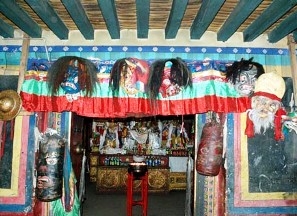
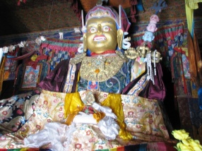
Tsetang has enjoyed great prestige throughout Tibetan history. The name "Tsetang" means "where the monkeys  play" in the Tibetan language, a reference to the story of the birth of the Tibetan people. The Prefecture, known as "the cradle of Tibetan culture", boasts many other firsts in Tibet in its long history besides the airport. The first king, Niechizanpu, the first palace (Yumbulagang), the first farming land, Suodang, and the first drama Bagabu were in Lhokha. Changzhu Temple was the first hall for worshipping Buddha, Samye the first Monastery, and the first Buddhist scripture Banggongqiajia are all to be found in Lhokha. Three out of the four holy mountains are in Lhokha: Jiasangqiuburi in Ganggar, Haburi in Samye and Gongburi in Tsetang. The two holy lakes, Yamdrok-tso and Lamuna-tso, are famous in Tibet, as is Lhokha's national scenic spot, Yarlung. play" in the Tibetan language, a reference to the story of the birth of the Tibetan people. The Prefecture, known as "the cradle of Tibetan culture", boasts many other firsts in Tibet in its long history besides the airport. The first king, Niechizanpu, the first palace (Yumbulagang), the first farming land, Suodang, and the first drama Bagabu were in Lhokha. Changzhu Temple was the first hall for worshipping Buddha, Samye the first Monastery, and the first Buddhist scripture Banggongqiajia are all to be found in Lhokha. Three out of the four holy mountains are in Lhokha: Jiasangqiuburi in Ganggar, Haburi in Samye and Gongburi in Tsetang. The two holy lakes, Yamdrok-tso and Lamuna-tso, are famous in Tibet, as is Lhokha's national scenic spot, Yarlung.
Lhokha's mild climate, beautiful landscapes and abundant water resources make it suitable for farming, animal husbandry and forestry. It has long been called "the breadbasket of Tibet". Fertile land stretches along both sides of the Yarlung Tsangpo River, natural grazing land spreads across Cuomei County and Langkazi County, and dense forests lie in remote valley in Nongzi County, Cuona County, Jiacha County and Luoza County.
Location
Lhokha Prefecture extends in an area between 90014" and 27008" east longitude, on the south of the Kailash and Nyainqentanglha Mountains, in the middle and lower reach of the Yarlung Tsangpo River. It adjoins Lhasa on the north, Shigates on the west, and Lingzhi on the east. It is bounded on the south by India and Bhutan. The total area is 73,500 km2. The national borderline in Lhokha is about 600 km long. Lhokha is in a very important strategic place and it's the southwest border area in China. The average altitude in Lhokha is above 3600 meters. Yarlung Tsangpo River, the mother river of the Tibetan people, flows through Kazi, Gonggar, Zanang, Naidong, Sanri, Qusong and Jiacha county, for 424 km. In addition, about 41 rivers cut through the mountains flowing continuously all the year round. In total, there are 88 lakes of different sizes, the most famous of which are Yamdrok-tso, Lamunamu-tso, Zhegu and Pumoyong-tso. These lakes are like jade-green gems set in the high mountains.
Features
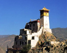
Lhokha is the most prosperous part in Tibet and has the longest history in Tibet. The well-known Tubo Regime (a historic period in Tibetan history) was derived from the agricultural civilization in Lhokha. Lhokha is also known as the source of the Tibetan civilization and has become the ruling center twice in Tibetan history.
Ranges, lakes, springs and river valleys constitute the featured landscapes. Yarlong Scenic Spot is the only national scenic spot in Tibet. You can find scenes of different types, snow mountains and glaciers, farming land and grazing land, holy mountain and sacred lakes, historic relics and simple folkways. All of these form a mysterious and wonderful picture. Yarlong is really a dazzling pearl in the Qinghai-Tibet Plateau. |